Sports
Loma Alta's New 680 Trail Opens for Hikers
Explore the new 2.8 mile "680 Trail," which connects Loma Alta to Terra Linda Open Space Preserve lands. Six to nine miles with 1,600' of elevation gain. Amazing views and scenery along mostly sunny grassland and dry mixed forest and chaparral. Dogs OK.


[Ed. Note: We contacted Marin County Parks Director Linda Dahl to clarify the reason the new 680 Trail is open to hikers but won't be open for bikes and horses until next spring. Here’s what she had to say: “The trail is wet and will be wet most of the winter and the impacts of the trail by bike tires and horse hooves is much greater in a wet climate. The reason that hikers are allowed and bikes and horses are not is that they have a much greater impact to a fragile new surface in wet weather than hikers do. I make my decisions solely based on the impacts of the trail, not politics.”
Dahl said she has directed park rangers to patrol the 680 Trail and issue citations to those using the trail in violation of the posted signs and info in the county’s website, emphasizing that the closure has the support of the Marin County Bicycle Coalition. “We’ve had bikes using the trail since it was finished and we already have damage up there,” she said.]
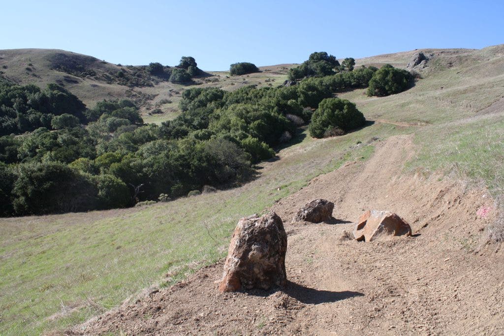
After what seems like years, and I think it has been, the new 2.8 mile-long "680 Trail," which contours across the front of Loma Alta and continues over to Terra Linda Open Space Preserve, is now open.
Find out what's happening in Mill Valleywith free, real-time updates from Patch.
There has not been an official opening ceremony and some of the signage is not up yet, but Marin County Parks has been kind enough to open it up. 680 Trail is a wide multi-use trail cut deep into the hillside. Multiple well-crafted bridges and some decorative rockwork show the hard work and care that went into building the trail.
One of the key features of the trail is that it opens up the connection between Terra Linda Open Space Preserve and Loma Alta Preserve, which was . Now those living in Sleepy Hollow or Terra Linda can hike up to the top of Loma Alta from various access points along the Terra Linda Open Space Preserve. Previously the only access was from Fairfax or the Big Rock Ridge trailhead.
Loma Alta, standing at almost 1,600', is one of Marin's highest points. It is clearly visible from San Rafael and dominates the landscape at the end of Sleepy Hollow. With only grassland and a few protruding boulders at the top, the 360 degree view makes the long trek more than worth it.
We have seen some unique wildlife in the area as well. This time of year the Western Blue Birds winter in the area and have been seen on the grassy slopes perched on posts, or on small scattered shrubs. There is a large boulder patch at the west end of the new trail and we have often seen a Red Tailed Hawk perch there, which seems to have little fear as we pass under it. Bobcats and coyotes are also fairly common in the area.
Now the big question: "How the heck do you get up there?"
There are three general entrance points. First is in Fairfax near White's Hill at Brown Bridge; second entrance point is Terra Linda Open Space Preserve, which can be accessed from Sleepy Hollow, Terra Linda or Lucas Valley; third is across from Big Rock Trail head on Lucas Valley Rd. All options are long and are out-and-back unless you want to do the hike as a shuttle.
Here are the estimates for the various options to get to the beginning of the 680 Trail:
Find out what's happening in Mill Valleywith free, real-time updates from Patch.
- Distance from White Hill School to west end of 680 is 2.3 miles and 1100' of climbing.
- Distance from Brown Bridge to west end of 680 is 1.6 miles and 800' of climbing.
- Distance from Terra Linda to east end of 680 is 1.4 miles, 600' elevation
- Distance from Big Rock to high point near west end is 2.2 miles and 900' in elevation.
The 680 Trail is 2.8 miles long. So if you are doing an out and back you just double the trail length (5.6 miles) and add one of the options from above. This means that the shortest out-and-back option is 7+ miles. The shortest way to see it is to do a shuttle, which will make the trip about 5.8 miles.
We recommend doing the hike as a one-way shuttle trip. Leave a car near one of the entrances to Terra Linda Open Space in Sleepy Hollow. Then drive to Brown Bridge on Sir Francis Drake in Fairfax, which is on the way over White's Hill. Hike in and head up the extremely steep Gunshot Fire Road to Smith Ridge Fire Road and then to the entrance of 680 Trail. This way you get most of the climbing over quickly at the beginning of the hike. The remaining five miles after the climb are mostly downhill. At the high point of the trail, which is about half a mile in from the west entrance, there is a small unoffical trail leading up to Loma Alta peak. It is only a short distance and a must if you made it this far.
See the book "Hiking Marin: 141 Great Hikes in Marin County" for more details. Click here to go the Marin Trails website, where you can find more information about the book.